Foreman Phil's Favorite Place
Copyright © 2005 by Richard S. Platz
All Rights Reserved
Pleasant Lake Backpack
Marble Mountain Wilderness
August 1-6, 2004
A well-published secret
A barbershop chair is a hell of a place to chart
the course of a man's destiny. Yet as I sat draped for shearing
in Delilah's Hair Styling in Arcata, a middle-aged fellow
by the name of Phil stopped by to chat. Stationed in Happy Camp,
Phil turned out to be the Trail Crew Foreman for the Marble Mountain
Wilderness. This year, he lamented, no funding was available for
his crew. He and I fell into swapping backpacking tales.
Phil announced that Pleasant Lake was his very favorite place
in the entire Marble Mountain Wilderness.
"Where's that?" I wanted to know, trying not to bob
my head beneath the snicking scissors.
"Up Bridge Creek," Phil replied.
"Bridge Creek? Where's that?"
"Well . . . let's see . . . if you go in through Haypress
. . . and cut over to Cedar Flat--"
"Oh, sure, Cedar Flat. We camped there once on the
way back from One Mile Lake. We dayhiked up to Medicine Mountain."
"That's Bridge Creek. Up the creek a ways is a spur trail
up and over the ridge to Pleasant Lake. The little lake hangs
on the eastern slope of the granite looking right out at Black
Marble and Marble Mountains."
"Your favorite place, huh?"
"Yup. Only one problem."
"What's that?"
"Lake sits in a steep granite bowl. There's only one good
campsite."
The seed, having been sown, took time to germinate. Barbara and
I had talked of returning to Cedar Flat and maybe going back to
Medicine Mountain, which lies in the heart of the Marble Mountain
Wilderness. According to Karuk legend, this was the center of
the Earth. In 1992, a couple of years after becoming aware of
the degenerative arthritis in my right hip, we had hiked to the
top of Medicine Mountain, where we had each beseeched the Karuk
gods to cure our respective ills. Now, twelve years later (and
after a total hip replacement in 2000) I prance about in the wilderness
as if my hip had never been diseased. Perhaps my prayers were
answered. Perhaps not. But even if the Native American gods had
nothing to do with it, returning to update our supplications certainly
couldn't do any harm.
So the idea of extending our journey beyond Cedar Flat
to the favorite lake of the Trail Crew Foreman resonated with
our latent aspirations. Pleasant Lake grew even more attractive
as we read the Forest Service wilderness map, rating its use as
moderate, in contrast to the heavy use of the nearby
lakes along the Sandy Ridge Trail. It occurred to me that no one
else knew about Pleasant Lake. And certainly no one else
had overheard Foreman Phil at Delilah's barbershop. Tentatively
we suggested Pleasant Lake to Mr. Popper as an alternate destination
for our group backpack in July, but to no avail.
So on Sunday afternoon, August 1, 2004, we set out for Pleasant
Lake. After an early dinner in Willow Creek, we motored north
on Highway 96 through Weichepec and Orleans, to Somes Bar at the
confluence of the Klamath and Salmon Rivers. From there we drove
up Forest Road 13N03, past Olfield Saddle with its sweeping view
of the western Marble Mountain highlands, to Camp Three, the site
of an abandoned logging camp in the tall forest. We had once van-camped
there before dayhiking into Haypress Meadow and considered again
stopping for the night, but because the next day's hike would
be long, we pressed on to the trailhead to get an early morning
start. The road climbed another thousand feet in the next five
miles.
At 4540 feet and 18 miles from Somes Bar, the Haypress Meadow
trailhead sits at the site of old logging Camp Four, the only
patch of level ground around. The parking area has recently been
improved with a graveled surface and a luxurious new pit toilet.
Vehicles enter from the south, and hikers and equestrians exit
on a narrow trail at the north end. We parked the van in the shade
of a fir grove by the entrance and moved our gear off the bed
for the night. Only three other vehicles were parked in the lot.
We had the place all to ourselves.
After dinner we explored the locale. The main road continued
eastward a tenth of a mile to a wide turnaround for horse trailers
and a relatively secluded campsite. We might have camped there
for the night, had we known about it. Beyond that, the mountain
dropped off into a canyon, where we could hear Haypress Creek
cascading 200 feet below. On the far side of the canyon would
be Let'er Buck trailhead, though neither of us had ever been there.
A different series of logging roads puzzles its way through the
steep terrain to that trailhead. The Haypress trail is carved
into the west slope high above Haypress Creek, the Let'er Buck
into the east. The two trails climb to meet two miles north at
Let'er Buck Meadow, southeast of Haypress Meadow.
We climbed the main road back past the parking area turnoff. Wide
shoulders for horse trailers to pull off had been provided with
hitching posts. A rusty pipe fed a trickle of water into a stock
trough. The place was obviously popular among folks of a horsey
bent. The prior week's fires in the Willow Creek area had left
a haze over the landscape. Cooler temperatures and north winds
expected for the coming week should clear the air.
All was well as darkness fell. We climbed into the van and were
soon sound asleep. We dreamed of forgotten things, perhaps of
sugars plums, perhaps of a contented locomotive chuffing placidly
down a pine-scented track in the night.
Suddenly a blinding white locomotive headlight pierced my dreams.
I awoke disoriented. "The hell was that?"
Car doors slammed. Someone laughed.
"What time is it?" Barbara muttered.
I looked at my watch. "Uh . . . midnight. D'ya'think they're
pirates?"
All we had to protect ourselves were a mushroom knife and a corroding
can of pepper spay. If we could locate them. Not
much defense against the cutlass and flintlock.
High beams from a second vehicle swept our van in a full-body
search as it roared past and crunched to a halt beside its companion
at the north end of the parking lot. Laughter and loud talking.
A flashlight beam swept our privacy. We propped ourselves up and
gazed through our mosquito netting at the group milling about
in the headlights of two vehicles. They didn't look like
pirates.
"No," Barbara whispered. "Young people."
They spread out tarps and tents and sleeping bags and generally
celebrated the night, oblivious to the their elders' desire for
a sound night's sleep. After maybe twenty minutes, which seemed
to take an hour, the commotion subsided and all lights were quenched.
We fell back asleep.
Five weeks after the summer solstice, the sun still rose early
Monday morning. I wanted to slam doors and bang pots together
by way of instruction, but Barbara said no. Instead, we spoke
in low tones and clicked the doors softly shut as we heated water,
then drank tea and mocha in our chairs at the private end of the
van. By the time we had eaten breakfast and were sorting through
our possessions, the young people were up. I walked over to palaver.
Four clean-cut young men in their late teens or early twenties
were headed for Onemile Lake to fish. They seemed polite and pleasant,
not at all the depraved, ecstasy-gobbling ravers I had imagined.
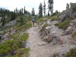
We were on the trail at 8 a.m., just ahead of the four young
fishermen.The trail immediately encountered a single steep switchback
in a rocky 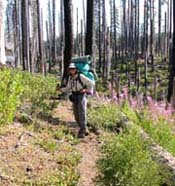 outcropping
and climbed 200 feet in the first quarter mile, then contoured
high above Haypress Creek, climbing gently through the Douglas
fir forest. The young men quickly overtook and breezed past us
with an exchange of pleasantries. We plodded on, dropping into
several wet ravines carpeted with lush green ferns, thimbleberry,
and vanilla leaf, then climbing steeply on the other side. A forest
fire had burned through at the crest, and an army of tall snags
marched over the ridge and descended to the grassy bank of the
Haypress Creek crossing at 4840 feet. The forest had begun to
regenerate with new saplings. The standing deadwood was full of
birds and other wildlife, and flowers were abundant along the
creek's green swale. outcropping
and climbed 200 feet in the first quarter mile, then contoured
high above Haypress Creek, climbing gently through the Douglas
fir forest. The young men quickly overtook and breezed past us
with an exchange of pleasantries. We plodded on, dropping into
several wet ravines carpeted with lush green ferns, thimbleberry,
and vanilla leaf, then climbing steeply on the other side. A forest
fire had burned through at the crest, and an army of tall snags
marched over the ridge and descended to the grassy bank of the
Haypress Creek crossing at 4840 feet. The forest had begun to
regenerate with new saplings. The standing deadwood was full of
birds and other wildlife, and flowers were abundant along the
creek's green swale.
At the fine campsite on the far side, the young fishermen had
taken off their packs and were resting. I unclasped the belt of
my pack for safety and, using both walking sticks, tight-roped
over the precarious rock crossing, then returned to carry Barbara's
pack across. Barbara, unencumbered, used two sticks to follow.
We chatted with the young men and asked one to take our photograph.
As if on cue, one after another each of them pulled out his own
camera and asked us to take their pictures.
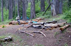
We pressed on ahead past Haypress Meadow to where the Haypress,
Stanshaw, and Let'er Buck trails converge. On two previous occasions
we had camped there in a broad flat parceled by fallen deadwood.
At the main campsite we greeted a man in the company of a young
boy, a younger girl, and two dogs. Slight, bespectacled, perhaps
in his early forties, he bore a strong resemblance to our postman
in Blue Lake. They had spent the night there and were just packing
up to move on.
"Where y'headed?" I asked conversationally.
"Pleasant Lake," he informed us. "Hope t'camp
there tonight."
A cold fist squeezed my heart. Phil, the Trail Crew Foreman, had
told me there was only one good campsite at Pleasant Lake,
and now this imposter postman and his unruly dogs and spawn were
bound to beat us there.
"Ever been there before?" I wanted to know.
"Nope. Never."
"How'd you learn about it?"
"A fellow I know told me about it," the postman responded.
"Said it was his favorite place. He heads the trail crew
up here."
Somberly we pressed on as my hopes evaporated of having the one
good campsite at Pleasant Lake. Who else had Phil blabbed his
secret to? The postman and his retinue quickly overtook and passed
us. We would encounter them twice more on the trail as we took
turns resting and hiking past each other. But there was never
any doubt who would get to Pleasant Lake first. Cedar Flat was
about as far as Barbara and I could hike in a single day.
The trail began its climb up the forested moraine toward the
Sandy Ridge 1400 feet above, but we would be turning off at the
Half Moon trail before it got really steep. The map showed the
junction to be less than two miles ahead. The trail rose and fell
over a series of ridges, ever climbing, arcing north and south
in great, unnecessary slaloms around a series of meadows we had
trouble identifying. After an hour, tired and dismayed, we stopped
to get our bearings. We had already climbed 400 feet above Haypress
Meadow. I had not felt it necessary to enter into the GPS the
coordinates of the Half Moon trail junction. How could we miss
it? But had we missed it? Or had we taken a wrong turn?
Retracing our steps was not palatable, so we resolved to press
on for another fifteen minutes and see where this path took us.
Our resolve had just about run out when the trail crossed a substantial
little stream, then rose to a trail junction. The stream was Half
Moon Creek, and our trail followed it down to Half Moon Meadow
on the right. Someone was resting at a horse camp sheltered in
the trees beside the creek on the edge of the meadow. Barbara
thought it was the postman. We made a note that this might make
a fine campsite on the way out, leaving a four mile stretch back
to the van. As the trail began to climb away from the creek, we
stopped for lunch on a sunny hillside.
The trail now had to climb out of the Half Moon Creek basin and
drop into the Bridge Creek valley. Slowly we lumbered up the slope
in the afternoon heat. Only halfway to our destination, we were
already tired. Our packs dragged us down. Suddenly a pair of small
dogs were nipping at our heels, so for the last time we stood
aside and watched the postman and his crew pass. They hiked with
discouraging vigor, even the young girl, whose pack appeared as
heavy as she was. The trail continued to climb annoyingly up the
slope in the tall fir forest.
More than six miles from the trailhead, we crested a ridge and
finally began the long contour downward. The valley far below
would harbor Bridge Creek. Barbara moved ahead as I slowed to
guard my left knee. One painful step after another, the seventh
and eighth miles were the hardest. It was not any particular
pain--although the cutting shoulder straps and aching lower back
would have been good candidates--but the overall burning
of fatigue, the longing to be finished, the certainty that old
folks were not meant to bear forty- and fifty-pound packs so long.
Barbara immersed herself in the landscape, wild and rugged, with
its tall canopy of trees and lush green understory. Her feet,
though weary, sang the descending trail. I concentrated on my
breathing and snippets from the Prajnaparamita, expecting
nothing, so my heart would not break at the sight of endless trail
stretching on beyond each fruitless bend.
Hot and tired and craving freedom from our burdens, we finally
arrived at the valley floor and a junction with the Bridge Creek
trail. We did not stop, perhaps could not, but ascended
the creekside path northward. It was already late afternoon, and
our blood sugar levels were lower than a snake's hips. Everything
ached. As in a dream, we at last crossed a pretty little streamlet
and noticed how stunning the giant Douglas firs and incense cedars
had become. We had arrived at Cedar Flat. According to the map,
Cedar Flat was the historical site of a cabin. Nothing remained.
Just below the junction with the Medicine Mountain trail, a small,
level clearing, perhaps the cabin site, was bisected by a massive
rotting cedar log. This was the same snag, now fallen, that had
teetered menacingly over our tent the last time we had camped
here years ago.
 We
dropped our packs and for a long time merely sat, exhausted, waiting
to recover that sweet fruitland of calm, which had been inundated
by prolonged misery. A rational civility was slow to return. Simple
questions, like on which side of the log should we plant the tent,
were slippery, elusive, irritating. In frustration, I changed
my sweat-soaked shirt and wandered through the brush trying to
orient myself. Eight miles was a long way to go. We
dropped our packs and for a long time merely sat, exhausted, waiting
to recover that sweet fruitland of calm, which had been inundated
by prolonged misery. A rational civility was slow to return. Simple
questions, like on which side of the log should we plant the tent,
were slippery, elusive, irritating. In frustration, I changed
my sweat-soaked shirt and wandered through the brush trying to
orient myself. Eight miles was a long way to go.
Our thirst drove us down the Medicine Mountain trail a quarter
mile to the crossing of Bridge Creek, flat, wide, rushing, and
crowded by alder, blooming dogwood, thimbleberry, and ferns. We
filled our water bottles and gazed up at the mountain's imposing
dome. The pretty streamlet back up the trail was probably a closer
and easier water source, but this way we got to explore and reminisce
about our prior visit and the bear we had seen crashing through
this brushy creek bottom.
The campsite had been improved since our last visit. Sitting
logs had been stacked around a large stone fire ring, and benches
cut into the rotting pulp of the fallen snag. The afternoon was
warm, with very few bugs. We set up camp, built a fire, and ate
dinner. Our rope for hanging food was missing, probably left at
Bullard's Basin on our last hike. Bears visited Cedar Flat, so
we utilized the clothesline to hang the food. We saw a Pileated
Woodpecker, Red Breasted Nuthatches, and an Olive Sided Flycatcher.
In the evening we pulled on our down jackets and sat before the
fire, chilled from exhaustion as much as from the cool breeze
blowing down the canyon. Thunder rumbled in the distance, but
no rain fell. Cow bells clanked unseen across the creek towards
Medicine Mountain. The inferno of the long hike had burned away
our worldly worries, even my obsession with the gentle postman.
We would find a place to camp at Pleasant Lake. Or not. What would
be, would be. No blame. Of this are adventures made. We crawled
into the tent early and slept deeply.
On Tuesday morning we took our time breaking camp. The previous
day's hike had been long and undulating. Today's would be short
and steep. Cedar Flat sat at an altitude of 4600 feet, barely
fifty feet higher than where our van was parked at the trailhead.
To reach Pleasant Lake, we would have to climb 1300 feet and drop
400 feet in little more than three miles. But we had all day to
do it.
The trail ascended the Bridge Creek bottom through lush ferns,
vanilla plant, thimbleberry, and grass, across muddy seeps chocked
with alder brush, and over dry terraces of granitic moraine. To
the west the thick forest rose toward the unseen Sandy Ridge high
above, and to the east, across the alder-choked creek, loomed
the stark granite rim over which we would have to scramble, running
north from Medicine Mountain to the Salmon Mountains crest. The
valley narrowed as we climbed, crowding us toward the creek. The
brush thickened.
Suddenly something crashed nearby to our left. Something big.
"Look!" Barbara whispered, stopping.
A huge stag was regarding us beneath an impressive, multi-forked
rack of antlers. This proud beast was no deer. We took a step
back. Apparently satisfied that we understood whose valley this
was, the elk slowly turned its broad back and crunched away into
the brush. When we resumed hiking, more crashing sounded from
other locations on our left. Through a clearing on the right we
spotted more than a dozen Roosevelt elk on the slope beyond the
creek. We had hiked smack into the middle of a whole herd. Big
yellow signs posted along the highway at Prairie Creek Park caution
visitors never to approach these dangerous animals. Here on Bridge
Creek it was not entirely clear who had approached whom, although
in a territorial battle, that point might not carry much weight.
Proceeding cautiously, hoping not to divide a mother from her
calf, we followed the trail a quarter mile through the brush to
a crossing of Bridge Creek at 5000 feet.
At the crossing, we paused for a break beside the babbling stream.
Beyond this point Bridge Creek circles west to climb to its source
at Meteor Lake, but no trail goes that way. Our trail left the
creek and climbed northeast up a canyon to the junction with the
Pleasant Lake trail 400 feet higher. Rising steeply through increasingly
drier forest, this section seemed longer than the half mile shown
on the map. By the time we reached the trail junction, we were
seriously tired, so we took off our packs for another break. The
morning was almost gone.
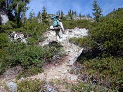
The Pleasant Lake trail cut back southeast onto sparsely forested
moraine beneath the rugged granitic ridgeline we would have to
cross. At first it was surprisingly well-constructed with an even,
moderately steep grade that would easily accommodate horses. We
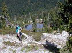
soon arrived at a small, shallow pond full of granite islands,
chiseled from the rim overlooking the Bridge Creek valley. The
granite crest across the valley to the west would be the Sandy
Ridge, and through the binoculars we thought we saw segments of
trail.
 Beyond
the little pond, the trail deteriorated. We began to climb an
impossibly steep track of loose granite rocks and sand zig-zagging
through the manzanita. It became difficult to tell the trail from
the cascade of dry washes. Half-buried granite fragments were
jagged and loose like steps in a badly constructed staircase.
Our feet slipped on sand-covered rock. In places the route became
a vertical scramble, and we had to use our hands to steady and
pull ourselves up, hoping not to dislodge a loose boulder. Our
walking sticks dangled uselessly from our wrists, clattering against
the rock. The trail led up through a jagged, narrow cleft in the
white rimrock. Coming back down would be a problem, but for another
day. Beyond
the little pond, the trail deteriorated. We began to climb an
impossibly steep track of loose granite rocks and sand zig-zagging
through the manzanita. It became difficult to tell the trail from
the cascade of dry washes. Half-buried granite fragments were
jagged and loose like steps in a badly constructed staircase.
Our feet slipped on sand-covered rock. In places the route became
a vertical scramble, and we had to use our hands to steady and
pull ourselves up, hoping not to dislodge a loose boulder. Our
walking sticks dangled uselessly from our wrists, clattering against
the rock. The trail led up through a jagged, narrow cleft in the
white rimrock. Coming back down would be a problem, but for another
day.
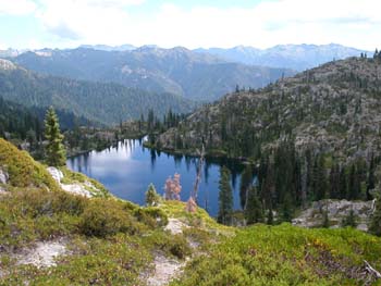
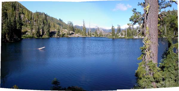
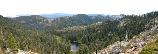
At last we reached the ridgetop, and a new world opened out before
us (see opening photo). Four hundred feet below Pleasant Lake
was set like a sapphire in white granite. Beyond, the world dropped
precipitously into the vast, wild, and trailless upper forests
of Wooley Creek. On the horizon stood Marble Mountain, notched
by the Marble Gap. Black Marble Mountain crowned its northern
flank.
Many trails seemed to descend the open, rocky moraine toward
the lake. Perhaps it made no difference, but we tried to follow
the most prominent. Though steep, it was not as tough as the scramble
up from the Bridge Creek side. We contoured south to a gentler
slope that took us through a broad swale to the lake's thickly
forested southwest shore. The main track led directly to a fine
campsite in the trees and brush where two tents had been pitched.
Dogs began barking and yapping as we approached. The postman shushed
them and greeted us like old friends.
We asked about campsites. He told us that he and the kids had
not circled the whole lake, but they hadn't seen any. As far as
he could tell, there was no easy way through the heavy brush around
to the south. But two backpackers had arrived at dusk the previous
night and circled north around the lake. They were camped somewhere
over on the granite lip.
We climbed up over the massive slabs of a granite bulge that
dropped abruptly into the water and found a place to rest and
have lunch overlooking the lake. It was not clear how, or even
if, the trail continued through the boulder field. After some
experimentation, Barbara found a trail higher up the slope. It
dropped down through a swale to the trees on the north shore.
After lunch, we strapped on our packs to see where it led.
We passed through a steep, rocky woodland, which ended at a large
grassy crescent of meadow spangled with a profusion of wildflowers.
Yellows and whites were splashed with blue gentian. There, beneath
a grove of red firs, we found the traces of an old campsite. Above
was a rocky outcrop with an overgrown fire ring. Long-neglected,
the place felt raw and wild, but it might do in a pinch. Leaning
our backpacks against the red firs, we explored further.
A footpath continued through the knee-high meadow grass, then
climbed onto a series of rocky, glacier-polished ledges overhanging
the valley below. In a gravel flat on one ledge sat two tents
with no one around. The views of Marble and Black Marble Mountains
from that site were spectacular, and I wanted to take a small
site just below on another ledge. But it would have been too close
to the other campsite. And there was no shade.
Barbara argued for the protected campsite in the meadow beneath
the red firs. I leaned toward the exposed granite shelf with the
view. In the end, after agonizing compulsively over the choice,
I relented. The level area in the duff beneath the trees was just
too small for our tent. Besides, the trunks and brush hid the
lake. 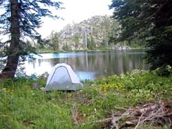 But
by matting down the grass at the lake's edge, we would have shelter
and a view of the lake, if not the Marble Mountain. As we stomped
down the tall grass, we discovered channels and deep holes pocking
the meadow, and wondered what made them. We weren't anxious to
have a marmot tunnel up through the bottom of our tent as we slept.
We finally found sufficient solid ground for the footprint of
our tent and pitched it there. As it would turn out, Barbara's
counsel proved wise when the winds came up the next day. We stuffed
rocks into the largest holes to keep from breaking an ankle in
the night. But
by matting down the grass at the lake's edge, we would have shelter
and a view of the lake, if not the Marble Mountain. As we stomped
down the tall grass, we discovered channels and deep holes pocking
the meadow, and wondered what made them. We weren't anxious to
have a marmot tunnel up through the bottom of our tent as we slept.
We finally found sufficient solid ground for the footprint of
our tent and pitched it there. As it would turn out, Barbara's
counsel proved wise when the winds came up the next day. We stuffed
rocks into the largest holes to keep from breaking an ankle in
the night.
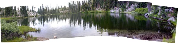
Tent erected, we eased into the lake for a swim. Ah, baptism!
Nothing places a pilgrim there in the wilderness like a
refreshing swim. The water was unexpectedly "warm."
No heart-stopping shock and life scramble for the beach. We paddled
out and swam in the deep for a while. Naked in the tall grass
beside the water we sunned ourselves, clean and purified, until
a dark-bottomed cloud sailed across the sky. Dark clouds threatened,
but no rain fell. Even in the grass, bugs were few.
A wildly bearded man and teenage boy approached on the trail
which ran through our campsite. They were father and son, the
owners of the tents we had seen on the exposed ledge, and were
returning from a failed attempt to cross-country along the ridge
crest to Medicine Mountain.
"Just too rugged up there," he explained.
We chatted a bit. The man seemed to know something about wildlife
and was of the opinion that the large holes and trenches in the
meadow were made by mice, pointing out little piles of dried grass
lying in a rut he believed they had harvested. We never saw any
mice. But we believed him.
I asked if he had ever been here before.
"Nope. First time."
"How'd you hear about the place then?"
"Trail Crew Foreman recommended it to me. Said Pleasant
Lake was his favorite lake in the Marbles."
Incredible. Pleasant Lake had become a well-published secret.
 After
dinner I hiked out on the granite ledge and took pictures of the
sun's last light kissing the western face of Marble and Black
Marble Mountain. Tired from two days of exertion, Barbara stayed
at camp and watched for birds. We sat by the fire until the bats
came out, then went to sleep. After
dinner I hiked out on the granite ledge and took pictures of the
sun's last light kissing the western face of Marble and Black
Marble Mountain. Tired from two days of exertion, Barbara stayed
at camp and watched for birds. We sat by the fire until the bats
came out, then went to sleep.
Wednesday morning we had nowhere to go, so we lay in our hammocks
with mocha and tea and enjoyed the birds in the meadow and trees:
brown creeper, junco, robin, chickadee, red breasted nuthatch,
red breasted sapsucker, flicker, Wilson's warbler, phoebe, and
olive sided flycatcher. After a leisurely breakfast we hiked out
on the slick rock ledges overlooking the forested valley and tried
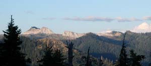
to identify the distant peaks. To the northeast the cleft whiteness
of Marble Mountain was easy. Due east rose the raw granite massif
of the Wooley Creek rim, beyond which lay Campbell, Cliff, and
Summit Lakes, and the Pacific Crest Trail running north above
Sky High Lakes and through the Marble Valley to Paradise Lake.
We had hiked that trail and visited each of them.
We turned back to our own lake and explored along the east side
to a secluded bay at the southeast corner, from which the unnamed
outlet stream flowed down into Pleasant Valley to join the Cuddihy
Fork of Wooley Creek. The stream coursed through the bottom of
a rocky, brushy gorge below us. One small, but beautiful campsite
sat on the other side of the stream, but we couldn't figure out
how to get to it. The whiskered man and his son had made it across
to begin their climb up the spine in their failed attempt to follow
the crest to Medicine Mountain, but we could find no clear path
through the thick manzanita choking the gully floor. Our hearts
weren't into a brushy scramble, so we gave up. The wind picked
up, and we were glad we were not camped out on the exposed granite
lip.
The postman and his kids were fishing from the big rocks along
the south side of the lake. That meant they had discovered the
secret passage through the brush from their campsite to the south
shore. After lunch we hiked around to their camp and asked about
it. The postman pointed out a short scramble up the steep bank
on the far side of the rocky inlet wash, which led to a trail.
We followed the trail and explored the rocky south shore. It was
rough going up and over huge, jagged boulders, which had tumbled
from the crest, but we found two nice campsites there. It would
have been tough to reach them carrying backpacks at the end of
the long climb into the lake.
The weather was warm and sunny, so we returned to our camp and
went for another long, refreshing swim. Toward evening, a cold
fog drifted in and the temperature dropped to 48 degrees by 7:30
p.m. We pulled on our down jackets, built a crackling fire, and
sat in its glow until an early darkness fell. That night we heard
a great horned owl nearby.
Thursday we awoke to sunny and clear skies, but cold. The thermometer
read 35 degrees. The inside of our rainfly was dripping wet. Whisps
of fog danced on the lake. We broke camp around 10 a.m. and began
our climb up and out of the Pleasant Lake cirque, not certain
where we were bound. Rested and in no hurry, we found the climb
through the manzanita and granite rocks and scree comfortable.
At the crest, we tarried to rediscover the Bridge Creek vista
and bid farewell to Wooley Creek.
 In
my usual obsessive-compulsive manner, I insisted on going over
my Rules for a Safe Descent. Barbara endured
the lecture good-naturedly, then led the way gracefully down the
cliff to the sparkling green pond without event. There the trail
improved, and as we hiked, we discussed our next destination.
Should we return down Bridge Creek, or loop north and west to
return via the Sandy Ridge trail? The weather radio forecast "a
slight chance of rain" after midnight, which had to factor
in. Today's hike would be pleasant, but we would not make it out
in one day, so where would be best to spend a night in the rain? In
my usual obsessive-compulsive manner, I insisted on going over
my Rules for a Safe Descent. Barbara endured
the lecture good-naturedly, then led the way gracefully down the
cliff to the sparkling green pond without event. There the trail
improved, and as we hiked, we discussed our next destination.
Should we return down Bridge Creek, or loop north and west to
return via the Sandy Ridge trail? The weather radio forecast "a
slight chance of rain" after midnight, which had to factor
in. Today's hike would be pleasant, but we would not make it out
in one day, so where would be best to spend a night in the rain?
Soon we arrived at the Bridge Creek trail junction. A left turn
would lead us back down to Cedar Flat and the long, viewless haul
to Half Moon Meadow. Turn right and we would have to climb a thousand
feet in two miles to reach the Sandy Ridge trail, then follow
the scenic Sandy Ridge five or six miles back to Half Moon Meadow.
Three or four lakes along the high route would offer camping that
night. My unnatural predilection for loops was exposed, discussed,
and factored in. In the end, we both surrendered to the spectacular
beauty of the Sandy Ridge and, even though that route was a mile
longer, turned right.
The Bridge Creek trail climbed relentlessly north through old
growth fir forest, then swung westward below the Salmon Mountain
Rim. At a little rivulet in a wet meadow we topped off our water
bottles, since there would be no water on the Sandy Ridge. The
stately timber opened in a series of dry, sloping meadows, revealing
views of the Sandy Ridge, Medicine Mountain crest, and the forested
green valley of Bridge Creek.
Just as we began to wonder how two miles could be so damned far,
the ridge above began to descend to meet our climbing trail. We
finally arrived at the junction with the Sandy Ridge trail and
dropped our packs. On the rounded ridgetop in a dry field of small
yellow and white flowers, we ate lunch overlooking Onemile Lake
(where the four young fishermen had been bound the first day)
and the broad Klamath River Valley beyond. Turning back east,
we could once again see the Marble Mountain and the notch we had
climbed through to reach Pleasant Lake. Far to the west a dark
streak of clouds and fog approached from the ocean. We decided
not to hike down to Onemile, nor backtrack to Cuddihy Lakes, but
to press on to either Meteor or Monument Lake.
 The
hike south on the Sandy Ridge trail was as spectacular as we remembered.
Barbara had come this way twice before, I four or five times.
The trail cut through a maze of manzanita, granite sand, and rock
atop stunning razorback ridges and rocky notches, then snaked
from east slope to west slope of the anchoring knolls. The knolls
were forested with ponderosa and whitebark pine, red fir, and
an occasional pale incense cedar. The weather front pressed closer
from the west, crowding us as we hiked. Haze began to filter the
sunlight. Before too long fog would engulf the ridge. The
hike south on the Sandy Ridge trail was as spectacular as we remembered.
Barbara had come this way twice before, I four or five times.
The trail cut through a maze of manzanita, granite sand, and rock
atop stunning razorback ridges and rocky notches, then snaked
from east slope to west slope of the anchoring knolls. The knolls
were forested with ponderosa and whitebark pine, red fir, and
an occasional pale incense cedar. The weather front pressed closer
from the west, crowding us as we hiked. Haze began to filter the
sunlight. Before too long fog would engulf the ridge.
After a while we dropped to an exposed razorback saddle above
Meteor Lake. Below us the lake was a shallow green circle surrounded
by thick forest. The outlet flowed east, away from us, through
a lush meadow on its way to becoming Bridge Creek. Directly across
the valley was the familiar granite saddle we had scaled to get
to Pleasant Lake. In the distance to the northwest lay Marble
and Black Marble Mountains and nearer to the south Medicine Mountain.
No one appeared to be at Meteor Lake, and we were weary, but we
decided to press on to Monument Lake to be closer to the trailhead
when the foul weather hit.
The trail stretched on and on. Low clouds obscured the sun. At
long last we descended to another exposed saddle opposite Medicine
Mountain. Cedar Flat was hidden in the trees 1500 feet down. Directly
before us lay the Monument Lake cirque with the green lake beckoning
in the trees three hundred feet below us. As the ridge trail dipped
toward the trail junction, we heard loud voices and a barking
dog, and wondered if we had blundered. We had not particularly
enjoyed our last visit there, crowded together with a score of
other hikers like some bizarre Disneyland family-value theme park.
Youngsters of all ages leapt yelping off rocks into the deep water
while parents barbequed. Everyone wore swimming suits.
Through the binoculars the main campsite on the lake looked
vacant, but what if we were wrong? If we were to descend the long
trail and find the place crowded, with no pleasant place to camp,
we might not make it back out before the weather socked us in.
But neither of us wanted to hike back to Meteor Lake or on to
Half Moon Meadow, so we started down the path cut into the rocky
west slope of the cirque. The switchbacks were needlessly long
and gentle, obviously designed to accommodate equestrians. Barbara
went on ahead. When we finally reached the lake, no one was in
sight. So we took the big horse camp in the trees and began to
unpack.
As we were setting up camp, fingers numb from fatigue and the
engulfing dampness, a parade of brooding teens emerged silently
from the trees to fill their bottles at the lake's north shore.
A young woman approached us to explain that she was leading a
drug and alcohol rehab group. Their camp was out of sight in the
forest, so as not to interact with other campers. I related our
unpleasant experience with Boy Scouts at Ukonom Lake. She smiled
and promised that they would be silent, because that was an essential
part of the program. Soon they all melted back into the forest,
and we neither saw nor heard them again.
We had Monument Lake all to ourselves. It was an incredibly beautiful
and peaceful place. The camp was in a grove of enormous, stately
red firs and offered a wonderful sandy beach, although the weather
had grown too windy, cold, and overcast to swim. Instead, we pulled
on our down jackets. When it was time to gather firewood for dinner,
the ground was bare, as if the place had just been vacated by
an obsessive troupe of vacuum salesmen. We had to hike back up
the trail and into the woods to find a sufficient quantity of
downed limbs and branches.
After dinner, we hiked part way around the lake and found the
old campsite we had occupied when the lake crawled with campers.
Fog had moved in to obscure the ridge above. We returned through
a lush meadow filled with flowers and corn lilies and battened
down for rain, breaking up our precious firewood and stacking
it neatly between two trees, covered with a plastic garbage bag.
Darkness fell early as the clouds pressed down on us.
We awoke Friday morning to find that no rain had fallen. How
lucky! As we sat with our tea and mocha gazing out over the placid
water, the breeze began to bear a mist, which gradually grew into
a very light drizzle. We scrambled to take down the tent before
it got wet and gathered our belongings in the dry circles around
the tree trunks. The drizzle turned into a light rain as we sat
for breakfast. From a fairly dry harbor between two massive trunks
we watched the rain come and go. Each wave was a little heavier
than the last and penetrated a bit deeper on the rising breeze.
Then it was time to pack up our wet gear and strap on our packs.
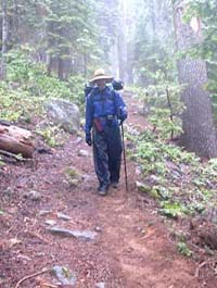 In
our GoreTex jackets and rain pants, we plodded up the long switchbacks
to the socked-in Sandy Ridge trail at 6100 feet. There were no
grand views that day. Visibility on the crest was no more than
a quarter of a mile. Stoically and blindly we plodded down the
trail, rising another hundred feet, then beginning the long 2200-foot
descent to our van. In
our GoreTex jackets and rain pants, we plodded up the long switchbacks
to the socked-in Sandy Ridge trail at 6100 feet. There were no
grand views that day. Visibility on the crest was no more than
a quarter of a mile. Stoically and blindly we plodded down the
trail, rising another hundred feet, then beginning the long 2200-foot
descent to our van.
The fog, low clouds, and drizzle accompanied us all the way to
Haypress Meadow, which we passed by unrecognized in our foggy
tunnel vision. At the Haypress Creek crossing the rain finally
ended. Patches of blue sky teased us as we crossed the creek and
hiked over the burned area and through canyon back to the trailhead.
We reached the van around 4 p.m. after more than six miles of
hiking. When we had removed our backpacks, one dazzling blaze
of full, hot sunlight served as our valediction.
Return to Backpacking
in Jefferson
|