The Coffee Pot's Grow'd Fur
Copyright © 2004-2005 by Richard S. Platz
All Rights Reserved
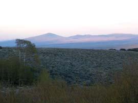
Hart Mountain-Warner Peak Backpack
Hart Mountain National Antelope Refuge
May 31-June 3, 2004
Their ghosts did not trouble our sleep
Fur covered the coffee pot, or so it appeared through our head
nets. A half-inch pelt of fine pale bristles the color of sagebrush
had grown on the pot while we washed the dishes and the sun dropped
below the surrounding hills. A cool draft wafted down from the
snow banks above. I lifted my net and bent closer. The fur, of
course, was not fur. Hundreds of mosquitoes crowded together on
every surface of the aluminum pot to borrow a little heat from
the warm water inside.
Above the embers of our fire clouds of mosquitoes wheeled like
tiny Sandhill Cranes above the Wilcox Playa. They whined around
our head nets, swarmed in our exhalations, and bent their proboscises
on our windbreakers and rain pants. A few fought through the DEET
to drill exposed patches of skin.
Bottom lip itching and beginning to swell, I dropped my head
net and moaned, "How did we get here?"
We had not intended to return to the Hart Mountain National Antelope
Refuge a mere one year after our first backpack there, but a fragile
brew of fate and circumstance brought us back. I had telephoned
all the usual ranger stations with the usual late May outcome:
the high country trails of the Klamaths were covered with snow
and blowdowns, the lakes frozen, and the creeks too high to cross.
Every May brings new hope and fresh disappointment.
Then I received a return call from the Biologist at Hart Mountain.
The road to Blue Sky, she said, was open early this year. She'd
driven there and back just the day before and hadn't needed four-wheel
drive. From Blue Sky a person could hike up "on top."
We considered our scant options: poison oak in a low canyon of
the Trinity Alps, sunstroke in the Black Rock Desert, or snowshoe
up a ridge in the Warners. We decided to return to Hart Mountain.
By Lakeview, Oregon, we had grown weary of the drive, and the
cut-out billboard of a giant cowboy didn't improve the mood. Filling
the tank with cowboy high-test, we jogged north on 385, then followed
140 through the Warners to the Plush Cutoff. As we descended on
Plush, Hart Mountain rose before us in all its grandeur.
The Plush general store was closed, so we couldn't top off our
tank. We climbed the long gravel road up the Hart Mountain scarp,
and the receded shorelines of the drought-ravaged lakes and dry
desert sinks of the Warner Valley spread out on our left.
We arrived at the Refuge Headquarters around dinnertime. The
long drive had sapped our energy, and low blood sugar made both
of us edgy and dangerous. The inside doors were all closed. No
one seemed to be on duty, which, if irritating, was not surprising
for Memorial Day. Barbara perused the wildlife information posted
on the bulletin boards while I took my sweet time in the rest
room (always open) imbibing the sweet ambience of sage and solitude
through the screened window.
Together we examined the visitor book to see who might still
be in the refuge and where. Most had come for the holiday weekend
and would soon be history. While Barbara studied the list of reported
bird sightings, I began the task of filling out the required back-country
permit (no charge).
"What's the license number of the van?"
Suddenly a door slammed at the back of the building. Through
the window I spotted a sturdy young woman in a pale green uniform
approaching a government pickup truck of the same vague color.
Dropping the form, I scrambled out the door, vaulted down the
steps, and hustled around to the side.
"Yo!" I called.
The young woman paused with one hand on the door handle of the
huge four-wheel-drive truck, which dwarfed her. She wore short,
black curls, a short-sleeved shirt with some kind of emblem, short
pants, and hiking boots, and appeared to be in her late twenties.
"Can I help you?"
"Yes," I panted in the rarified air. "We're thinking
of backpacking . . . down in the south . . . part of the refuge,"
I began. She listened patiently as I prattled on about our being
there because all the other wilderness was under snow and the
lakes frozen and how we'd come here last year, trailing off with
a parade of questions about passable roads, Blue Sky, and where
to find water in the canyons.
When I was done, she said, "You're the one I talked to last
week, aren't you?"
I didn't deny it, but eyed her more closely. She appeared robustly
capable of tracking wildlife all day through the sage-covered
hills. "And you must be the park Biologist."
"Refuge, actually."
"Refuge?"
"You said ‘park.' It's actually a refuge. And yes,
I am, and the Blue Sky road is open."
"Can we make it in that?" I pointed to the van
in the visitor parking across the graveled yard.
"The road's in good shape. Dry. You shouldn't have a problem."
"Great! So we can camp tonight in our van at Blue Sky?"
"Actually, Blue Sky is closed to camping right now, to protect
the breeding grounds. There's a breeding pair of falcons we don't
want disturbed. But camping is allowed at Post Meadows nearby.
At the corrals. That's the only place you can camp in your vehicle
other than at the Hot Springs."
I asked about the trail up Hart Mountain I'd seen on the map
starting just south of Blue Sky. She told me that was a gated
road used only by park personnel. But, yes, it would be a good
road to hike up.
"Any water?"
"I can't guarantee you'll find water anywhere."
"Okay. I understand. Liability issues. But, off the record,
we will find water in the canyons, won't we?"
"This time of year, probably. In the lower parts, anyway."
"How about on that road up into Hart Mountain?"
She considered her reply. "Near the top, the road crosses
a canyon with aspen groves that usually have a stream running
through. But I don't know. I haven't been up there recently."
"How far up?"
She considered again. "Maybe two-thirds of the way."
I thanked her, and we piled unhappily back into the van. Hot
Springs campground was only four miles away, but we decided to
take her counsel and spend the night at Post Meadows. That would
give us an earlier start hiking in the morning.
Blue Sky lies a mere six-and-a-half miles south of the Hot Spring
Campground on the Barnhardy Road. Unfortunately, the Barnhardy
Road was closed. From the headquarters, our route followed instead
a graded dirt road for 15 miles as it looped through the next
valley to the east, with no fast food restaurants along the way.
Or any other signs of civilization. With the windows closed against
the rising dust cloud, we bumped along grumpily at 20 miles per
hour past Indian Springs, the Skyline Road, Lookout Point, Deer
Canyon, and the South Boundary Road. All the side roads were closed
and gated. We met no traffic, saw no other vehicle, only endless
acres of sagebrush spotted with a few dark junipers.
As we finally rounded the southern tip of the intervening range
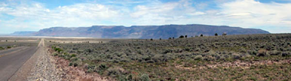
and curved west, flat-topped Hart Mountain rose like a table before
us. Etched into the eastern flank were two major canyons with
long snow fields just below their north-facing rimrock crests,
both arcing west-to-northwest as they rose. The canyon to the
south, the map told us, held Goat Creek, and that to the north
Stockade Creek. There we would surely find water. Both
creeks fed the broad wetland of Guano Creek flowing south along
the base of Hart Mountain. A sign marked "Post Meadows"
pointed left down a rutted dirt road toward the green wetland.
We bounced along the ruts, mostly dry, but with standing water
in a few dips, until we crested a ridge and spied a wooden corral
and a white-roofed forest service pit toilet in the distance.
We arrived at a flat, grassy parking area next to the corrals
and stepped out of the van, our journey completed (we thought),
to find a gentle westerly breeze, absolutely no shade, and mosquitoes.
When the wind gusted, they retreated into a carnivorous cloud
in the lee of the van. After slathering on insect repellant, we
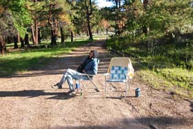
began to set up camp. I brought out the aluminum table, folding
chairs, ice chest, and stove. Barbara grabbed the binoculars to
look for birds in the broad green marsh. I relocated the van across
the rutted road so our heads would be up, and together we installed
our mosquito net over the back door opening. Barbara lit a mosquito
coil.
The wind died down, and the mosquitoes swarmed us. Word had gone
out, and they flew in from every quarter for the feast. We swatted
them with growing dismay. I leveled the little gas stove on a
bare patch of ground and brought out a match to light a fire under
the water pot. Like mourners at graveside, we paused numbly over
the small round casket. Mosquitoes flew in our faces. We had
to cook dinner. Mosquitoes whined in our ears. We had to
eat. Caught in one of those terrible Zen moments where we
could go no further, could not go back, and could not endure where
we were, a paralysis settled upon us.
"We can't stay here," I mumbled, the match unstruck
in my fingers.
"What do you want to do?" Barbara snapped, slapping
two mosquitoes irritably.
"We could drive back to the Hot Springs Campground. Come
back in the morning."
"Is that what you want to do?"
"What would you like to do?"
"It's your birthday."
My shoulders sagged. "Not for another three days."
The sun blazed over Hart Mountain. A red-winged blackbird called
from the desolate marsh. The mosquitoes grew thicker.
"We may not be able to backpack at all," I said morosely.
"You really think they'll be this bad up there?" Barbara
asked, poking a thumb up toward Hart Mountain.
"I don't know. I don't know anything."
We agreed to drive the 15 miles back to the Hot Springs Campground,
cook dinner, and sleep there. In the morning we could return for
our hike--if we were going to hike at all. Haphazardly we stowed
everything back into the van and left Post Meadows.
At the Blue Sky Road, Barbara suggested we go on another mile
or so to Blue Sky, as long as we had come this far. The implication
was we might not be coming back. I concurred.
The road joined Guano Creek and led up and away from the marshlands.
A mile from Post Meadows, snug in the lower canyons of the mountain,
lay the inviting dark green of the Ponderosa pine forest called
"Blue Sky." The road dead-ended at two locked gates
on the edge of the tall pines. Straight ahead lay the blocked
Barnhardy road. To the left, presumably, was the inaccessible
Blue Sky Lodge Campground. Nailed to a tree two prominent signs
read "No Camping" and "No Campfires." The
altitude was 6086 feet.
 I
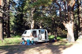
pulled the van into a clearing among the stout trees, and we got
out. The forest was tall and beautiful with pockets of luxurious
deep shade. Green grass carpeted the floor. The air smelled light
and, well, woodsy. The ambience was enchanting. To our
surprise, only a few wayward mosquitoes accosted us. There was
no reason we couldn't get out our propane stove and cook a little
dinner before moving on. That really wasn't camping, was
it? And who knows, after dinner we might just fall asleep in the
van, and that wouldn't really be camping either. No tent.
No need to build a campfire, of course, as the sign proscribed.
That might become camping, which we had no intention of
doing. Then in the morning we could lock up the van right where
it sat, strap on our packs, and begin our hike in the shade of
the pines. Who would know the difference? And even if they did,
we were not really camping. I
pulled the van into a clearing among the stout trees, and we got
out. The forest was tall and beautiful with pockets of luxurious
deep shade. Green grass carpeted the floor. The air smelled light
and, well, woodsy. The ambience was enchanting. To our
surprise, only a few wayward mosquitoes accosted us. There was
no reason we couldn't get out our propane stove and cook a little
dinner before moving on. That really wasn't camping, was
it? And who knows, after dinner we might just fall asleep in the
van, and that wouldn't really be camping either. No tent.
No need to build a campfire, of course, as the sign proscribed.
That might become camping, which we had no intention of
doing. Then in the morning we could lock up the van right where
it sat, strap on our packs, and begin our hike in the shade of
the pines. Who would know the difference? And even if they did,
we were not really camping.
 I
unfolded the chairs in the road and moved things off the bed into
the front seats while Barbara warmed up sausages in a pot on the
stove. We sat beneath the pines and ate a long-overdue dinner
as the shadow of Hart Mountain climbed the sage-green hills to
the east. Antelope wandered through the sage, more than we had
seen during our entire trip last year. DEET deterred the few mosquitoes
that sniffed us out, a mild annoyance after the saturation therapy
of Post Meadows. We decided we would be fine once we climbed away
from the Guano Creek wetlands the next morning. I
unfolded the chairs in the road and moved things off the bed into
the front seats while Barbara warmed up sausages in a pot on the
stove. We sat beneath the pines and ate a long-overdue dinner
as the shadow of Hart Mountain climbed the sage-green hills to
the east. Antelope wandered through the sage, more than we had
seen during our entire trip last year. DEET deterred the few mosquitoes
that sniffed us out, a mild annoyance after the saturation therapy
of Post Meadows. We decided we would be fine once we climbed away
from the Guano Creek wetlands the next morning.
We heard a vehicle approaching long before we saw it. Quickly
we moved a few things around to make it clear no camping
was taking place. A young man in a tan station wagon drove up
streaming clouds of mosquitoes. Every time he stopped to take
pictures, he complained, they swarmed him. We commiserated for
a while, then he U-turned and headed back up the Blue Sky Road.
We would not see another human for the next three days.
Alone again, we heated water, washed the dishes, and took a look
around. Beneath the long grass, the entire forest floor had recently
burned down to the duff. Charred sticks and charcoal spread evenly
among the trunks of the great trees, which were blackened to a
few feet above the ground. The lowest branches of a few smaller
trees had been burned, but the fire had not climbed into the forest
crown. We concluded it had been a successful controlled burn.
No trees had been killed, ground fuel had been eliminated, and
the forest protected.
That evening we hiked around the gate and up the road in search
of the fabled Blue Sky Lodge. The literature told us it had been
the site of an annual week-long meeting of The Order of the Antelope,
a group of local businessmen credited with lobbying for the establishment
of the refuge. Their annual blow-outs were controversial and are
now banned from the refuge, although the group still owns private
land somewhere within the refuge where it continues its activities.
We hiked up the several forest roads until satisfied that the
"lodge" was not an actual building, but simply an unmarked
site.
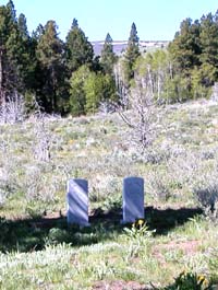 We
discovered instead two headstones standing at the site of old
Camp Warner, a U.S. Army military post established in 1866 to
protect settlers from marauding bands of Indians. The lonely marble
slabs marked the graves of Ward Cantrell, born 1846, died 1867,
and Lewis Debold, born 1847, died 1866, and testified to the harsh
conditions the soldiers endured during the winter of 1866-67.
The next summer (still two years before the completion of the
Transcontinental Railroad) General Crook relocated the camp westward
to a lower site in the Warner Valley. We
discovered instead two headstones standing at the site of old
Camp Warner, a U.S. Army military post established in 1866 to
protect settlers from marauding bands of Indians. The lonely marble
slabs marked the graves of Ward Cantrell, born 1846, died 1867,
and Lewis Debold, born 1847, died 1866, and testified to the harsh
conditions the soldiers endured during the winter of 1866-67.
The next summer (still two years before the completion of the
Transcontinental Railroad) General Crook relocated the camp westward
to a lower site in the Warner Valley.
Darkness fell as we found our way back to the van in the company
of two young soldiers who had died too soon. But if their ghosts
haunted those woods, they did not trouble our sleep that night.
We awoke at first light Tuesday morning and quickly moved a few
things around to erase any hint of camping, which we had
not done. I extracted our backpacks and leaned them against the
van. Satisfied, we deployed our chairs in the middle of the road
and drank our tea and mocha as the sun rose over the eastern hills.
Only a few lethargic mosquitoes whined by. Although my birthday
was still two days hence, Barbara insisted I open one present
before our hike, a nifty little LED headlight on an elastic band.
Well rested and in fine spirits, we loaded our packs, stowed
our gear in the van, and began our hike in the shade of the tall
pine forest. At the grave markers of Fort Warner, we emerged into
the blazing sun on a road running south down Guano Creek at the
base of Hart Mountain. In a half mile we located and verified
with the GPS the spur road that climbed west up the steep slope
of the foothills. After climbing a quarter mile we skirted a locked
gate that kept all but authorized vehicles from the upper slopes.
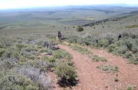
Not in a canyon, but on a dry broad loma of sage-covered
slope between canyons the road zig-zagged ever upward.
The jeep road was easy to follow, and we were able to walk side
by side. The few mosquitoes melted away in the heat, but as we
began to sweat and puff, they were replaced by a persistent cloud
of black biting gnats that floated like moats in a feverish eye.
We settled into a rhythm of swinging our arms with a final flip
of the writ to shoo them from our faces.
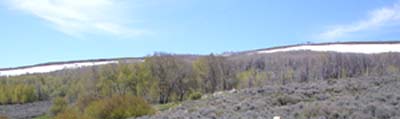
 Before
long the vista opened below us of the semi-arid desert valley.
The corral and outhouse sat beside the green sward of Post Meadows.
In the distance to the northwest hung the prominent snow-covered
slopes of Steens Mountain. Between the vast sage-green plain tilted
down toward the Catlow Valley. Before
long the vista opened below us of the semi-arid desert valley.
The corral and outhouse sat beside the green sward of Post Meadows.
In the distance to the northwest hung the prominent snow-covered
slopes of Steens Mountain. Between the vast sage-green plain tilted
down toward the Catlow Valley.
After endless switch-backs, the road finally veered to the left
to begin its southerly climb along a rock-strewn road beneath
exposed rimrock toward Stockade Canyon to the south. We stopped
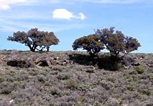
for lunch in the shade of a grove of short Mountain Mahogany.
Overhead the canopy was alive with the steady buzz of bees doing
whatever bees do in the dry dark-green branches of mahogany in
the otherwise treeless hills. A light breeze cleansed the shade
of mosquitoes and gnats, and we spread out a ground cloth, lay
back, and took our time gazing into the distance.
After lunch, the grade gradually eased as we finally surmounted
the shoulder of the mountain's steep eastern flank. We continued
up the road over a series of hummocks until we encountered a major
fork. The map showed the right fork leading north to 8065-foot
Warner Peak and beyond. We stayed left and continued to climb
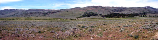
toward the upper reaches of Stockade Canyon. Soon we crested a
final bench onto the broad flat top of the mountain and saw the
welcome snowfields below the rimrock at the canyon's head. There
would be water, even if we had to melt snow to get at it.
 Our
road dropped into the half-mile-wide swale of upper Stockade Canyon
before rising again on the far side toward the flat bench of Hart
Mountain, now only a few hundred feet above. Beneath the snow
fields on the other slope lay groves of aspen. Patches of yellow-green
leaves were interspersed with webs of bare branches. We wondered
if fire or decease had ravaged those groves. The Refuge Biologist
had said we might find water flowing in the aspen groves along
the upper reaches of the trail, and that had to be the place. Our
road dropped into the half-mile-wide swale of upper Stockade Canyon
before rising again on the far side toward the flat bench of Hart
Mountain, now only a few hundred feet above. Beneath the snow
fields on the other slope lay groves of aspen. Patches of yellow-green
leaves were interspersed with webs of bare branches. We wondered
if fire or decease had ravaged those groves. The Refuge Biologist
had said we might find water flowing in the aspen groves along
the upper reaches of the trail, and that had to be the place.
Weary from our four-mile climb, we dropped carefully into the
broad, shallow upper canyon. Almost immediately the road crossed
the dry, rocky bed of Stockade Creek. Sharp black volcanic rocks
and banks of stubby brown grass gave no sign that water had flowed
there recently. We paused to consider our choices. We could follow
the dry creek bed down into the canyon however far it took to
reach water, or we could climb off-trail toward the aspen groves
high on the far side. We elected to stay high and left the road
for the aspen groves.
Hiking through the gnarly sagebrush was a struggle. Time and
again we stopped to concur on a route between the woody plants,
but even then with each step concealed branches poked our shins
and snagged our feet while black gnats swam unceasingly before
our eyes. Slowly, carefully, tediously, we clawed our way up the
steepening slope.
The aspens were just beginning to sprout new spring foliage.
Each bare branch was tipped with a green spearhead of new growth.
But no water flowed. Apparently the snow melt fed these dense
thickets beneath the surface. We considered melting snow, but
decided instead to follow the aspens down to running water.
From grove to grove we began an arduous descent through the unforgiving
sagebrush. Grove after grove disappointed us until at last our
boots post-holed into a wet green meadow with a rivulet trickling
through the muddy grass. We followed the trickle down to Stockade
Creek, where we could hear the tinkle of water flowing freely
through impenetrable thickets of willow and alder. A little further
down the small stream flashed merrily in the sunlight. We had
descended a difficult half mile. It would have been easier had
we hiked down the dry creek bed.
In an aspen grove on a knoll above the creek, with views of Warner
Peak to the north and down into Guano Valley to the east, we chose
our campsite. The altitude was 7122 feet, a thousand feet above
our van and five trail miles in. At first we rested on a log in
the sunny meadow listening to the wisdom of the creek. Small birds
flitted through the thickets and poked in the green grass among
corn lilies. Overhead a Northern Harrier soared majestically.
As our sweat dried in the sun and gentle breeze, the bugs melted
away. It was a fine place and a good day to be alive.
We set up our tent in the tall, matted grass. I built a fire
ring of rough rocks between the sage and the grassy high edge
of the aspen grove. The sagebrush, and not the wet meadow, seemed
to be the source of mosquitoes. This seemed odd. What were all
those mosquitoes doing in the sage? We decided to build a fire
early so the smoke would drive them off, but that resulted in
another oddity. Contrary to conventional wisdom, the insects seemed
attracted to the heat rising from the fire. So we slathered
on more DEET and prepared dinner.
 Mosquitoes
were becoming a true nuisance just as the sun sank early behind
Hart Mountain, and the temperature dropped 30 degrees in fifteen
minutes. The thermometer read 42 degrees, and the mosquitoes disappeared.
We put on our down jackets and laid back in our hammocks watching
the sunlight crawl across the valley below, soften, glow pink,
and finally lift off the distant hills. A silver moon hung low
in the east, almost full. We soon grew chilly, climbed into the
tent, zipped up our bags, and slept. Mosquitoes
were becoming a true nuisance just as the sun sank early behind
Hart Mountain, and the temperature dropped 30 degrees in fifteen
minutes. The thermometer read 42 degrees, and the mosquitoes disappeared.
We put on our down jackets and laid back in our hammocks watching
the sunlight crawl across the valley below, soften, glow pink,
and finally lift off the distant hills. A silver moon hung low
in the east, almost full. We soon grew chilly, climbed into the
tent, zipped up our bags, and slept.
Wednesday morning we were awakened by the early sun on the low
eastern horizon. The day started in the low forties and mosquito
free.
"Barbara, look!" I called in a hoarse whisper from
the hammock, mocha poised before my lips. Birdwatching in the
sage forty feet away, Barbara turned to see an antelope stroll
up from the creek and between us right through our campsite. Suddenly
startled to see us, the animal bounded away up the hill. That
was our closest encounter ever.
The day quickly warmed, and with the warmth came mosquitoes in
increasingly irritating numbers. Even before breakfast we had
to dig out our head nets and pull them on.
Warner Peak beckoned us from our campsite, and we decided a dayhike
there was in order. It didn't look that far away. We climbed the
dry creek bed to the road and followed it to a right-hand fork
we had come up the day before. We took the left fork through the
sage. Hordes of mosquitoes and biting gnats surrounded us. We
wore our head nets. We were finally hiking "on top,"
and it felt like the top of the world. Sage-covered plains and
hummocks of sparser brush were interspersed with wet grassy swales
at the canyon heads. At a second fork the cutoff road from Blue
Sky joined ours just before we skirted the stunning drop-off of
the Hart Canyon escarpment.
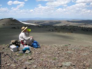 A
service road lead up the final quarter mile to some sort of radio
tower and a locked block building at the windy summit of Warner
Peak. At 8086 feet, this was the highest point for miles around,
and the views were magnificent. We found a spot for lunch on an
unobstructed rocky outcropping away from the structures. I crouched
on an old board that harbored a nest of ladybugs, a sign we took
for good luck. The breeze offered us some relief from the bugs. A
service road lead up the final quarter mile to some sort of radio
tower and a locked block building at the windy summit of Warner
Peak. At 8086 feet, this was the highest point for miles around,
and the views were magnificent. We found a spot for lunch on an
unobstructed rocky outcropping away from the structures. I crouched
on an old board that harbored a nest of ladybugs, a sign we took
for good luck. The breeze offered us some relief from the bugs.
As we ate, we fitted together the geographic puzzle. To the northeast
we traced our prior year's trip from headquarters, up Rock Creek
to the white scar of Hot Spring Campground, and our backpack over
the hill to DeGarmo Canyon. We saw the knoll we had circled, where
wedescended into Barnhardy, and the aspen grove that had sheltered
us the final night. To the southeast lay Blue Sky, Guano Creek,
and the dread Post Meadows. Far to the northeast rose the snowy
Steens and due east the Catlow Rim. 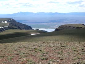 To
the west lay a spectacular view down the stunning Hart Canyon
scarp to Hart Lake and Plush and beyond to snow-speckled Drake,
Twelvemile, and Crook Peaks dominating the Fremont National Forest
highlands. To
the west lay a spectacular view down the stunning Hart Canyon
scarp to Hart Lake and Plush and beyond to snow-speckled Drake,
Twelvemile, and Crook Peaks dominating the Fremont National Forest
highlands.
The trudge back to camp was buggier than ever. The entire round
trip spanned about eight miles. Curiously, during most of the
trek we remained in sight of both our aspen grove and Warner Peak,
and our progress felt glacial.
Back at camp, the mosquitoes had grown worse. We ate dinner by
popping up our head nets just long enough to shovel in a bite
of food. Itchy bites accumulated, and after washing the dishes
we encountered the furry coffee pot and mosquito swarms first
described. Our only hope was for another 30-degree drop in temperature
when the sun sank behind Hart Mountain.
Alas, it did not happen like the night before. As the sun set,
the temperature continued to hover in the mid sixties, a perfectly
hospitable climate for the carnivorous hordes, only now we could
no longer see them through the gauze of our head nets. We were
flying blind amid the whine and prickle of blood-thirsty insects.
Fittingly, a blood-red full moon rose in the east. Before it was
fully dark we gave up and crawled into the tent. There we systematically
and with unbecoming relish squashed all intruders, leaving little
bloody squiggles like petroglyphs against the fabric ceiling.
Thursday was my birthday. We crawled out of the tent early to
find a party of mosquitoes already underway and robustly attended.
Donning our head nets, we agreed to cut our backpack short and
somberly set about breaking camp. We climbed the dry, rocky creek
bed until we attained our jeep road, and the rest was downhill.
The bugs were horrendous. Black gnats joined the mosquitoes as
we entered the sagebrush. The magnificent vistas that opened up
were obscured by the netting. We paused only occasionally when
an easterly gust drove the insects into our lee and we could raise
our nets. Without stopping for a single break we hiked down the
steep switchbacks, past a crop of mule ear sunflowers we had missed
on the way up, through the locked gate, around the grave markers,
and at last to our van.
Blue Sky was no longer the benign oasis we had left. Clouds of
mosquitoes, many of which were no doubt in our party, swarmed
into the van when the doors were opened. Without fuss we hoisted
our packs onto the bed and drove off with the windows rolled down.
A couple of miles up the road a pale green ranger truck approached,
and we squeezed to the right shoulder to allow it to pass. As
it crept past, we recognized the Refuge Biologist and waived for
her to stop.
"Where did all those mosquitoes come from?" I demanded.
She explained that the spring hatch had just started a few days
ago, and the mosquitoes will probably last about a month.
"But we were here last year at the same time and didn't
have any problem."
"This year May was very wet," she said, as if that
explained everything. "Last year the rains came in April,
and May was dry."
"Well," I grumbled, "this year has got to be worse
than ever. We hiked out a day early."
At Lookout Point we pulled off and unfolded our chairs for a
leisurely lunch. An easterly breeze kept the bugs at bay. We gazed
down Robinson Draw into the great shallow bowl of forsaken Black
Canyon, dotted here and there with a few white specks that were
grazing antelope.
Every trail's end should have a hot tub. We headed straight for
the Hot Springs Campground, doffed our sweaty clothes, and let
the hot mineral waters soak away the sweat and aches and itching
bug bites and disappointment. We had cashed in the third day of
our backpack for extra time, and the fat silver dollar hours and
small change minutes jingled in our naked pockets. But we were
in no hurry to spend them.
Back at the visitor center, I stepped inside to take down our
backpacking permit from the bulletin board, so no search party
would be sent out looking for our blood-drained husks. The permit
had already been removed. Noticing that the door in back was wide
open, I poked my head inside. In the dim light the black curls
of the Refuge Biologist were bent over a wide low work table busily
doing, well, biology things. I asked how she found the mosquitoes
at Blue Sky, and she admitted having to apply insect repellant,
which she rarely had to do.
I pondered a moment, then posed the question that had been troubling
me for three days. "Suppose . . . just hypothetically . .
. suppose that someone is sent to Post Meadows to spend the night.
Okay? But suppose the mosquitoes are really bad there. Unendurable.
Suppose . . . again just hypothetically . . . suppose that they
decide simply to sleep a few hours in their van at Blue Sky before
heading out on a backpack early the following morning. How would
you react to that?"
"Hypothetically? We would issue them a warning." Any
hint of merriment drained from her dark eyes. "But if we
knew they already knew the rules . . . we would issue a
citation."
I stumbled hastily into the more hospitable glare of the blazing
sun that burned the sage-green hills. We fled the Park Headquarters
like common criminals.
On the road to Petroglyph Lake a few insouciant antelope crossed
the road. The problem with a pocket full of free time is that
it has to be spent. All of it. None can be squirreled
away for another day. We felt the coins slipping steadily through
our fingers as we left Hart Mountain.
Return to Backpacking
in Jefferson
|